History of Gib Hill
A Brief Historical Context
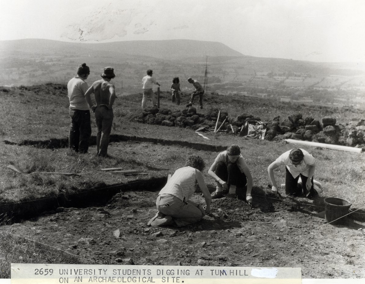
The Gib Hill Nature Reserve sits at the foot of the ancient hill fort and associated enclosures of Castercliff. The fort appears to date from the Iron Age, specifically the 5th or 6th century BC according to radiocarbon dating. It consists of the now buried remains of concentric ramparts encircling the fort, and a wider area of enclosures running around the slopes of Gib Hill, Tum Hills and the Lenches. It probably remained occupied during Romano-British times, possibly serving as a temporary Roman Camp, and into the Dark Ages.
In 1951, a young Colne lad, by the name of Geoff Crambie, on school outing to Castercliff, found two Roman coins there. Several archaeological digs in the 20th century found evidence of “vitrification” – the welding together of the stones by high-intensity fires – but whether this was by design or as a result of hostilities in unknown. A Manchester University dig in 1970 found some primitive iron smelting furnaces dating from 60-90 AD.
It is thought that the hillfort fell into disuse in the Dark Ages, although it’s a mystery how a 6-lb cannonball discovered on the hillfort got there. In more recent times, small-scale “bell-pit” mining has pock-marked the site, causing the various round hollows and ponds. For further information you can visit: Castercliff Hill Fort (Brigantes Nation) or Castercliff Hill Fort (Journal of Antiquities)
The South-eastern corner of Castercliff is the meeting point of two ancient routes. One of these probably ran from Hebden Bridge through the Thursden Valley, along the south side of Castercliff as a sunken trackway and down though the Nature Reserve, where it is known as Bannister Lane and Bott House Lane, and then onto Barrowford and beyond via the Swindon ford. It is generally agreed that this would have been in use in Medieval times, but could date back further considering the discovery of a number of Roman coins along the route. The second route possibly connected the various Romano-British settlements above Extwistle (Beadle Hill, Twist Castle and Ringstones), via Briercliffe and Catlow along Southfield Lane and past the East Side of Castercliff and then through the Lenches and Colne and possibly over to the Roman “A-road” and Fort at Elslack. Whilst this might be a little speculative, these settlements did exist in Roman times, so it would seem logical that there were a series of local “B-roads” connecting them up to the main Roman road.
With the exception of the stone wall enclosing the former Marsden Hall estate, the field boundaries on the hillside consist of hedge-lined ditches, rather than the dry stones walls of the fields beyond Southfield Lane. A possible explanation for this is due to the wider availability of stones in the shallow soil on the higher, drier ground, with the clayey lower slopes requiring drainage channels and being less able to support heavy stone walls. Whatever the reason, the hedges found along the field boundaries in the nature reserve provide a welcome boost to the local ecology and ecosystem.
When the current field boundaries on Gib Hill were laid out is not entirely clear, but the smaller fields on the lower slopes are somewhat random so it’s quite possible that they predate the enclosure acts which typically created long, straight lines in the countryside.
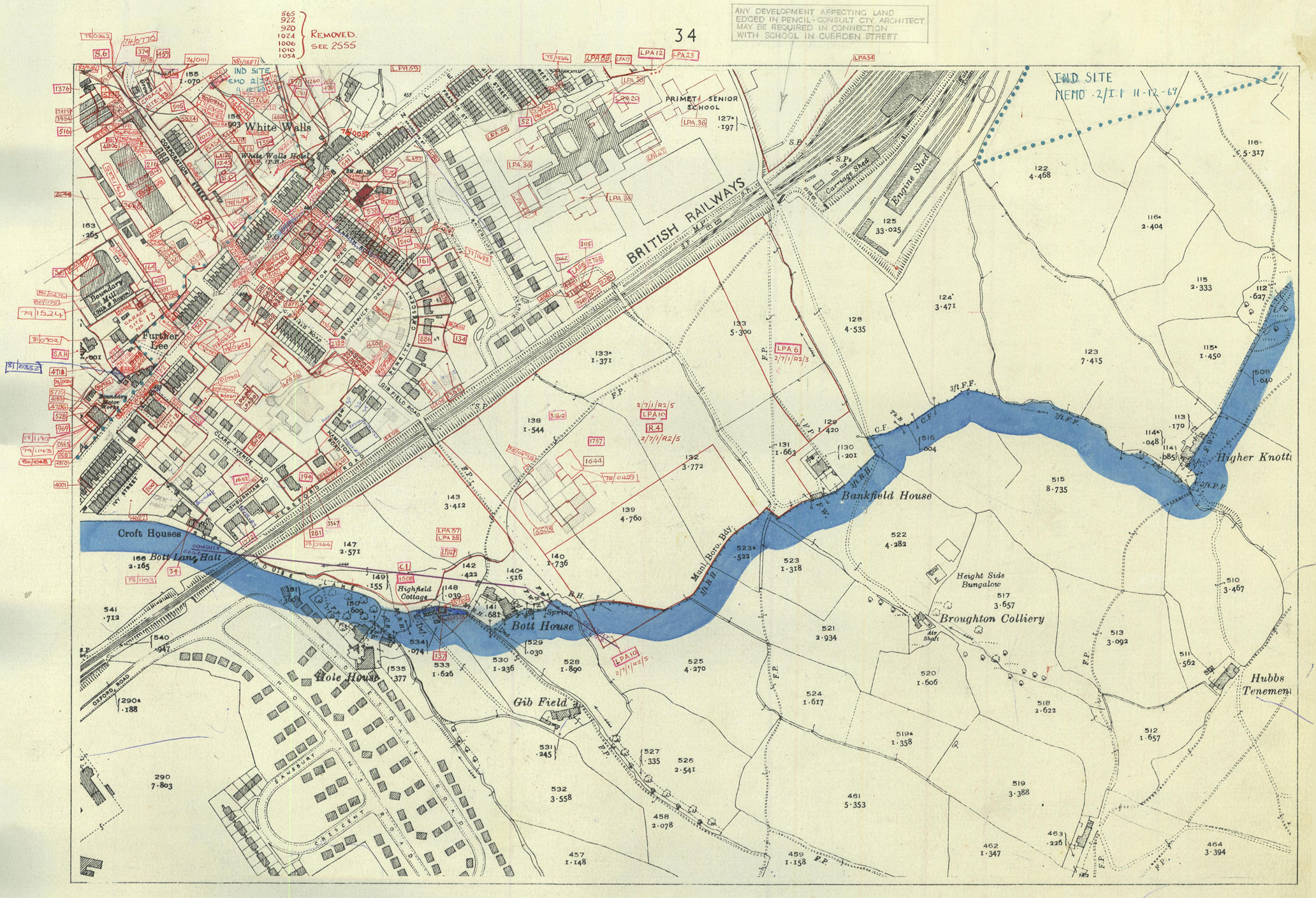
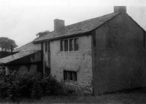
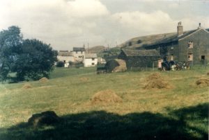
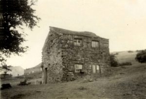
The 1849 Great Marsden Tithe Map and accompanying schedules, are quite a good source of information about how the fields in the Nature Reserve were farmed. There were several small farms around the hillside: Gib Field Farm and Bott House Farm, both sadly demolished now, Gib Hill Farm – the white building below Castercliff – Little Gib Hill Farm and Haggate Farm on Burnley Road.
Source: Red Rose Collection LCC
Source: Red Rose Collection LCC
Source: Red Rose Collection LCC
1849 Tithe Map
According to the 1849 Tithe Map (below), The Hartley family, of Hole House and Gib Field Farm owned and farmed the fields on the Nelson side of the Nature Reserve, whilst John Greenwood of Bott House Farm owned and farmed those fields on the Colne side. Interestingly, each farm also had a small orchard. The top fields extending from the golf course were part of the estate of Robert Townley Parker of Towneley Hall and farmed by a tenant farmer, Thomas Blackburn of Gib Hill Farm.
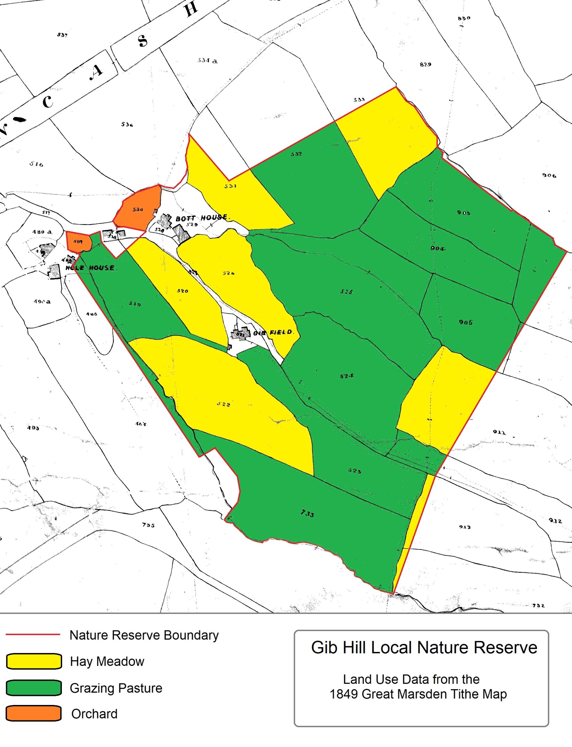
| Plot No. | Owner | Occupier | Description | Usage | Size |
|---|---|---|---|---|---|
| 484 | James Hartley | William Hartley | Clough Field | Pasture | 5 Acres 1 Rood 5 Poles |
| 485 | James Hartley | William Hartley | Clough Croft | Pasture | 2 Roods 23 Poles |
| 489 | James Hartley | William Hartley | Orchard | Orchard | 1 Rood 31 Poles |
| 490 | James Hartley | William Hartley | Little Croft | Meadow | 3 Roods |
| 516 | George Hartley | Martha Hartley | Square Field | Pasture | 2 Acres 2 Roods 14 Poles |
| 517 | George Hartley | Martha Hartley | Road from Railway to Well | Bott House Lane | 1 Rood 29 Poles |
| 518 | George Hartley | Martha Hartley | Houses, Gardens and Fold | Cottages | 1 Rood 20 Poles |
| 519 | George Hartley | Martha Hartley | Little Field | Pasture | 1 Acre 2 Roods 30 Poles |
| 520 | George Hartley | Martha Hartley | Little Meadow | Meadow | 1 Acre 0 Rood 39 Poles |
| 521 | George Hartley | Martha Hartley | Houses, Garden and Fold | Gib Field Farm | |
| 522 | George Hartley | Martha Hartley | Well Meadow | Meadow | 3 Acres 1 Rood 37 Poles |
| 523 | George Hartley | Martha Hartley | Higher Field | Pasture | 2 Acres 1 Rood 33 Poles |
| 524 | John Greenwood | Himself | Higher Stubbins | Pasture | 2 Acres 3 Roods 39 Poles |
| 525 | John Greenwood | Himself | Lower Stubbins | Pasture | 4 Acres 1 Rood 8 Poles |
| 526 | John Greenwood | Himself | Little Meadow | Meadow | 1 Acre 3 Roods 4 Poles |
| 527 | John Greenwood | Himself | Occupation road | 1 Rood 31 Poles | |
| 528 | John Greenwood | Himself | Garden, Houses and Fold | Bott House Farm | 3 Roods 15 Poles |
| 529 | John Greenwood | Himself | Garden, Houses and Fold | Bott House Farm | |
| 530 | John Greenwood | Himself | Orchard | Orchard | 1 Rood 25 Poles |
| 531 | John Greenwood | Himself | Marl Croft | Meadow | 1 Acre 2 Roods 34 Poles |
| 532 | John Greenwood | Himself | Broad Acre | Pasture | 4 Acres 3 Roods 23 Poles |
| 533 | John Greenwood | Himself | Farther Meadow | Meadow | 3 Acres 3 Roods 21 Poles |
| 733 | M Walton | Marsden Cock | Gib Field Meadow | Pasture | 4 Acres 1 Rood 31 Poles |
| 903 | Robert Towneley Parker esq. | Thomas Blackburn | Great Lane Field | Pasture | 2 Acres 0 Rood 33 Poles |
| 904 | Robert Towneley Parker esq. | Thomas Blackburn | Little Lane Field | Pasture | 1 Acre 3 Roods 21 Poles |
| 905 | Robert Towneley Parker esq. | Thomas Blackburn | part of Long Field | Pasture | 1 Acre 2 Roods 32 Poles |
| 911 | Robert Towneley Parker esq. | James H. Rushton | Meadow | Meadow | 5 Acres 1 Rood 10 Poles |
| 912 | Mrs Walsh | Bernard Hartley | Bannister Lane | Pasture | 2 Acres 1 Rood 9 Poles |
Before the 20th century, farms in England were typically small, relying on just manpower and horses for all the various farmwork activities and for local transportation. Horses require good quality hay and so hay meadows featured significantly on these small farms. However, due mainly to the manpower shortages and trade blockades of the two world wars, the need to greatly improve agricultural efficiency saw tractors, mechanised harvesters and trucks replace horses, so hay meadows were no longer needed. In East Lancashire, most hay meadows were ploughed up and re-sowed to grow mono-species fodder crops for silage. Hedgerows were ripped up, and stone walls torn down, to create much larger fields, easier to farm with mechanised equipment.
With the education reforms following on from the 1944 Education Act, Lancashire Council were wanting to build several new schools in Colne and Nelson which required the purchase of considerable amounts of land for the buildings and playing fields, and so they purchased several farms along the Colne-Nelson boundary for this purpose. School buildings got built, and land was set aside for future playing field extensions, waiting for funding.
In the 1970s some of the surplus land was transferred to Pendle Council for the golf course extension and some of the now disused farm buildings were demolished. Now that the farms had closed, the undeveloped fields could not be used for regular agriculture but were let out from time to time on short-term leases for grazing; the isolated position between schools, houses and the golf course made the fields unattractive for agricultural tenants. This meant that the Gib Hill fields escaped the intensification of agriculture, and associated contamination of the soil by chemical fertiliser and pesticides during the second half of the 20th century, to become the ecological time-capsule that they are today.
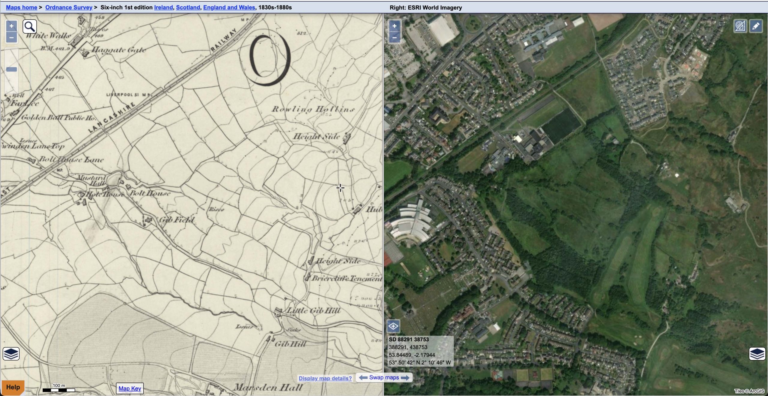
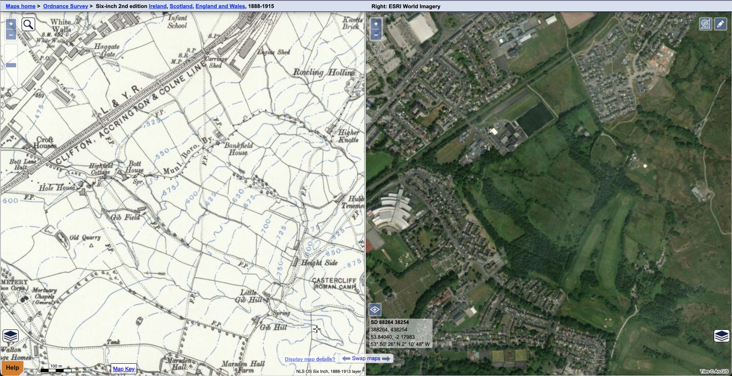
Historical Maps
In this section, we have assembled a range of historical maps of Gib Hill. If you click on the map, a larger version will open in a new window.
Gib Hill (1830s – 1880s) on the left, present day on the right.
Gib Hill (1888 – 1915) on the left, present day on the right.
Gib Hill in 1947